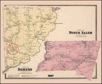
PUTNAM & WESTCHESTER COUNTY
CARMEL
In the spring of 1871 the prospect of extending the New York City & Northern Railroad to Carmel seemed favorable and to get in advance of this enterprise the Harlem Railroad Company planned a road from Golden's Bridge to Lake Mahopac. Articles of incorporation were speedily executed for the " New York and Mahopac Railroad " and the work of survey and building began at once and was so rapidly carried on that the first train ran through to the Lake on July 4th, 1871. Upon this occasion there was a grand celebration and Lake Mahopac was in the height of its glory. It was not until 1872 that freight and passenger trains were run regularly on schedule time.
History of Putnam & Westchester County (1886)
MAHOPAC (1)
Lake Mahopac, even on the earliest of maps, dating back to the American Revolution, was named Mahopac. This name is attributed to the Algonquain Indian word meaning “The Lake of the Great Serpent”. The Indian tribe that lived in this area were the Wappingers, one of the Algonquain Tribes.
During the French and Indian War, the Wappinger tribe moved their families north to Stockbridge, Massachusetts and with 300 warriors, fought on the side of the British. After the war, when they returned to Mahopac, they found that their lands had been taken over by settlers, who turned the land into farms. The Chief of the Wappingers, Sachem David Ninham, appealed to and even traveled to England to have the British Colonist government return the land to the Indians, but was refused and the land was lost forever.
All of the now Putnam County was given to one Adolph Philipse in a land grant in 1697 by King William III. By 1754 that lands of Putnam County were divided up by Mr. Philipse’s heirs and the area of Mahopac was owned by Roger and Mary (Philipse) Morris, a grand niece of Mr. Philipse.
The first settlers of the Mahopac area were tenant farmers who rented their land from the Morris’. The only exception to this was a large farm, which was sold outright to William Hill, after whom our present Hill Street is still named. Along with the farmers the need for businesses were filled; a few Inns, 10 delis, a small grist mill and an Iron Furnace Ship.
One of the first locations to develop was the corner of Route 6N, Hill Street and Myrtle Avenue. This was due to the fast running stream that flowed from Kirk Lake and Lake Mahopac, creating the necessary power to turn the large mill stones. A small mill was built in the early 1700′s and when the Morris’ saw the potential, they immediately built a much larger one, which was the largest building in all the county. This mill was to play an important part in the coming American Revolution. One of the original mill stones can still be found as part of the front steps of the Mills branch of the Mahopac Nation Bank. Since all of the building in the area were painted red, this area was called Red Mills for a long period of time.
Even though no battles were fought in the Mahopac area, it played an important part in the Revolution. Because of the size of the mill, it was guarded throughout the Revolution by soldiers so grain could be ground to supply the army with food. Mahopac was located on the main route between many area camps. We even claim that General George Washington spend time in the Inn of Captain John Crane, a marker for which is located on Route 6, at the intersection of East Lake Kirk.
After the Revolution, the tenant farmers were allowed to purchase the land from New York State, which took title to all lands after the war. The area remained primarily farmland until the mid 1800′s when it was discovered as a vacation spot because of its close location and beauty. The first hotel was built in 1843 and was called the Mahopac Hotel. Many more were to follow; the Gregory House (The Gregory House was owned by Louis Horton Gregory who was instrumental in developing Mahopac into a tourist attraction), the Carpenter House, the Baxter Hotel, the Thompson House, the Dean House and the Forest House. In addition to the hotel industry, other local businesses were logging, iron ore mining and because of the crystal clear waters of the lake, ice for New York City.
The original location of the town of Mahopac has been changed three times. It was first centered on Croton Falls Road, south of the now present Fire house and McAlpine Avenue. When New York City (in 1871)
took title of lakes in the area for their water supply, the village was burnt down because it was polluting the stream that lead into the reservoir. The town then moved up the hill to what is now McAlpine Avenue. It consisted of a school, the community hall (town hall in the center of the road), a boarding house, livery stable and a general store and a few houses. In time, with the establishment of Route 6, the business district was moved to its present location.
Mahopac, a nice place to live and work…says the Chamber of Commerce. Mahopac, a part of the Town of Carmel, houses all town government, including the police department. It has always been known for its lake; the joy of swimmers and boaters in the summer, skaters and ice boaters in the winter and fishermen all year round.
At one time, Mahopac was known for its hotels and as a summer resort. Today the weekenders have become year round residents. There are many activities for all, including two golf courses, cultural and historic centers,and both historic and modern houses of worship.
Industrial development is still in its infancy, but in these past years outsiders have come to inspect the community and see its possibilities.
MAHOPAC (2)
Mahopa is a hamlet in the south-west corner of the town of Carmel in Putnam County. From Lake Mahopac to the Red Mills there is a fall of 126 feet and from the water flowing over the dam at the mill the locality gained the name of Mahopac Falls.
Although no battles were fought in Mahopac during the American Revolution, the area was strategically important due to its location. With troop encampments in nearby Patterson, Yorktown, West Point and Danbury, Connecticut, it was a cross-roads between key Colonial garrisons. Soldiers were stationed in Mahopac Falls to guard the Red Mills, an important center for grinding grain and storing flour for the American troops.
Mahopac Falls
In colonial times a large gristmill sat near the present-day intersection of Route 6N, Hill Street and Myrtle Avenue. Drawing its water from the streams that drained Kirk Lake and Lake Mahopac, it was the largest building in the entire county. Early settlers to the area, tenant farmers renting land from the Philipse family, provided grain for its wheel. Over time the mill's red paint came to identify the area, known to this day as "Red Mills". It was the falls of the waters of the pond that drove the mill that gave the larger community comprising the southern half of the hamlet of Mahopac the name "Mahopac Falls". Although the famous mill there is gone, one of its original millstones forms a part of the front steps of the Red Mills Branch of Mahopac National Bank.
Lake Mahopac, contains three islands, Fairy, Petre and Canopus, all privately owned. Fairy Island sports multiple homes accessible via a short causeway; Petre boasts the Massaro House, a Frank Lloyd Wright-inspired residence and a Wright-designed bungalo, the A. K. Chahroudi Cottage; Canopus is undeveloped. Boating, fishing and other water sports are permitted on the lake. Slips and support services are provided by two marinas.
Besides Lake Mahopac, other lakes within the Mahopac CDP include Kirk Lake, Lake Casse, Lake Secor, Teakettle Spout Lake and Long Pond. Lake Mahopac is within the Croton River watershed yet not a part of the New York City water supply system's Croton Watershed. Kirk Lake, a controlled lake in that system, is both.
HISTORIC MAHOPAC
The history and tradition that cluster around Mahopac are interesting. Attractive to the Indian and white man alike, it has been the theater of many thrilling scenes in modern as well as olden times. It was once the pride of Dutchess County, but since the division, authorized by the Legislature at Albany, Putnam County has boasted of her charms. In early times it was simply known as " Big Pond", but when the Hughson family became prominent, owning the whole north side of the lake, it took the name of "Hughson Pond". When Erskine's military map was published it was named "Mahopac Pond." "Ma-hopac" is an Indian word meaning "Great Lake". "Big Pond" seemed to be the most popular name and was used for many years. The lake was originally bought by Adolph Philipse from the Indians. Later this purchase was attacked, but the Philipse title was declared valid and Lake Mahopac with her surrounding country was known as Philipse Patent. Here is where the story of the gallant Washington comes in. He met Mary Philipse in New York City. She invited him to her country estate, which consisted of about 40.000 acres and included Lake Mahopac and her settings. The young Southern gentleman fell in love with the country and the lady. By marrying one he could get the other. It would have been a lucky stroke for Father George. Just about that time the tea was dumped overboard in Boston Harbor and soon after Warren fell at Bunker Hill. The young lady was loyal to the throne beyond the sea, while the young man refused to pay homage to any king save only the King of kings and so they parted; each went their way: Washington to fight for the Declaration of Independence and Mary Philipse to marry Col. Roger Morris, who had fought side by side with Washington at Braddock's defeat and afterward was in the battle on the Plains of Abraham when the two brave generals, Wolfe and Montcalm, fell. After the Revolutionary War all the land belonging to the Tories, Roger Morris and his wife, was sold by the Commissioners of Forfeiture. Previous to 1834 the lake was scarcely known to the outside world. In that year Stephen Monk came from Connecticut, bought an acre of land adjoining the lake and erected the first boarding house and hotel at Lake Mahopac. This afterward became the site of the famous Gregory House. The father of the boarding house and hotel business at this watering place was called "Old Bolivar". He was an interesting old character. He never became rich. He did not understand the fancy prices and long list of extras, but a good, jolly, old soul was he. I have talked with some old inhabitants who knew him well. He was one of the leading local citizens, liberal and generous, a great lover of music and children. He died when fifty-six years old, leaving a wife and seven children. He was laid to rest in the Crane burying ground. Huldah Gregory bought the Mahopac Hotel that Stephen Monk had started together with one acre of land. Another piece of land joining this and a part of the old Peter Mable farm was previously bought by her from the administrators of the Daniel Baldwin estate. Both pieces of property were conveyed by her to her son, Dr. Lewis H. Gregory, January 26, 1853. This was the beginning of the famous old Gregory House, which in its day was equaled by few and excelled by none of its kind anywhere and did much to make Lake Mahopac so well known. From the time that these two estates were consolidated and the Gregory House formally opened until it was burned to the ground, Dr. Gregory was identified with the progress and development of the hotel business at Lake Mahopac. While Mr. Monk was the father of the industry, it was Dr. Gregory who gave it character and dignity and elevated it to the high grade which his successors so wisely maintain to-day. The Gregory House in fashion and splendor rivaled anything that can be found at Newport or Saratoga. It was burned to the ground October 2, 1878. The "Mansion House", built from an old dwelling house, was burned January 18, 1857. It stood opposite the Mahopac Hotel.
In 1853 Reuben C. Baldwin built the famous "Baldwin House" and ran it successfully for ten years. In 1869 it burned and was not rebuilt. The carriage house and barn are still standing and presumably some one is living there, for on the outside of the back door over the casement are these words, B-A-R.
In 1858, John W. Carpenter came to Mahopac and built what is known as the Carpenter House. This is a good summer house and has some fine trees about it. It is now run by Walter Carpenter. The old Lake House stood where the Catholic church now stands. It was bought by the Cole family and bore their name until recently, when it was burned to the ground.
Previous to 1849 the natural highway to the lake was from Peekskill. After the Harlem Railroad was built to Croton Falls it was from that point. By a special act of legislature commissioners were appointed to straighten and improve the highway that ran between Croton Falls and Lake Mahopac. Over this highway great coaches from the different hotels at the lake traveled to meet the Harlem trains. These coaches were drawn by four, six, eight and even ten horses. Back over the hills and through the dales they raced. Some of the old inhabitants tell of the spectacular scene often witnessed when the Gregory House coach, drawn by ten white horses, endeavored to pass the Baldwin House coach, drawn by eight black horses. As they reached the far end of that level stretch just beyond the site of the new town the real race began. It was the home stretch and the natives came for miles every evening to see it. Side by side they raced for half a mile, the black team and the white; first one and then the other ahead, much to the delight of the passengers. Perhaps Lew Wallace took one of these flighty rides and thus caught his inspiration for the chariot race in "Ben-Hur".
In the spring of 1871 a movement was set on foot to extend the New York City and Northern Railroad to Carmel. This was brought about by the influential members of the Lake Mahopac Improvement Company. The directors of the Harlem Road, at that time a competitive company (and we all wish it were now), hurriedly called a meeting and planned to build a road from Golden's Bridge to Lake Mahopac. Articles of incorporation were speedily executed and the work of construction began at once. The first train run from New York to Mahopac was on July 4, 1871. A great celebration was held; Mahopac was in all of her glory. The formation of the land companies of Mahopac, their wild speculations, brief life and death are treated of elsewhere. At the north end of the lake are two old homesteads. Around them some fine old trees are clustering. About them there is an air of quiet dignity and reserve. Their beautiful green lawns reach all the way down to the waters of the lake. One, "Graymanse", is owned by Mr. Dewitt Smith, of New York City; the other, "Longmead," is owned by Mrs. Nathan K. Averill, also of New York City. Both of these estates are a part of the old farm of Robert Hughson, who bought it directly from the Commissioners of Forfeiture. Up to a comparatively recent date this old Hughson farm retained the simplicity of other days. It was sold by the heirs of Hughson to Stephen Dingee. Benjamin Ballard bought it from Dingee. Selah Ballard bought it from his brother's heirs and sold it to Lewis R. Griffin and he sold 24 acres of the original tract to William Tilden, who erected a magnificent stone mansion, the most handsome structure of its day, not only at Lake Mahopac, but in all Putnam County.
In December, 1900, Mr. Smith bought this property and at once began very extensive improvements on it. He has spent more than $100.000 in this work. He built the most substantial and artistic boat-house at the lake, laid out a beautiful Italian garden, with a well in its center. Flowers, trees, riprap wall, beautiful lawns and winding walks make one think of those old Roman estates on the shores of Southern Italy. The old Griffin farm was bought by Isabel Saportas, July I, 1863. She built a home for herself on it along the shore, which she occupied for some time. This house is situated just west of the outlet that flows from Wixsom's Pond and now joins the property of Mr. Dewitt Smith. Some time later Mr. Peter B. Sweeney, of New York City, bought this place and paid $47.000 for it. The handsome trees that grace its lawns, the big broad walks that reach from the house to shore, the unique fence that encloses it, the grading and many other similar improvements were done by Mr. Sweeney. The landscape artist who planned this work was General Viele, who laid out Central Park, New York City. The site of the old homestead is one of the finest at the lake. Both sides of the group of islands can be seen from its lawns. The old Griffin family graveyard is just across the road to the north of "Longmead". Another historic site is the "Kaufman Place" at the other end of the lake and just south of the Carpenter House. This is situated on the old Drake farm and in itself was originally a tract of 99 acres. At one time it was sold by Henry S. Baldwin to Samuel Kaufman, who spent more than $150.000 in improvements. Later Mr. Lowerre, of Yonkers, N. Y., bought the property and has spent much time and money in beautifying the place. It possesses an air of dignity and character as it stands up among tall, stately trees and adds much to the charm and beauty round about that portion of the lake shore. Over the railroad is what is recently known as the Card property. Mr. Lowerre has bought this fine site and purposes to erect a villa of summer cottages thereon. It is truly a magnificent view from the lifted heights of this villa site, whether it is to the north over the lake and islands, or to the west, east and south over the rolling sylvan stretches. Many people sojourn this way looking for summer homes; finding none, they go elsewhere. When this plan is realized it will in part supply this demand. There are some large trees and shady groves gracing the sloping sides of this site as well as other natural beauties which, when properly used by the landscape artist, will beautify and adorn the proposed little summer villa. To the southwest of this site and overlooking the lake is what is known as the Mt. Hope Cottage. The owner of this place, F. C. Bivens, lives here. It is of historic interest. Originally it was a part of the Peter Mable farm and then came into the hands of Mr. Baldwin. When he sold his property to Mr. Kaufman he reserved 30 acres on the very crown of the hills and built this present house, expending more than $20.000 in its erection. The old gentleman lived here many years. Later this property came into the hands of Mrs. F. C. Bivens, the only surviving member of the old Baldwin family at Lake Mahopac. There is a curious spring up here throwing up about 100 gallons of pure water per hour. It has done this for forty years. And still another curio found up here is a gold, feldspar and quartz mine. It is called the Crow Hill Mine and was discovered by Mr. F. C. Bivens in 1902, who opened the mine and worked it to some extent, shipping the feldspar to Trenton, N.J. and the quartz to Still River, Conn., leaving the elusive gold hidden away in her earthen pots that some adventurous spirit might sojourn here and buy the whole hillside in order to get the goose with the golden egg. Ricketts & Banks, chemist assayers, have given certificates of analysis for these minerals that have been mined. Gold has been found in large quantities on the Pacific Coast, but Crow Hill Mine stands alone along the Atlantic shore as possessing the precious jewel. There are many fine places at Lake Mahopac and some not so fine. It is impossible to mention all of them. Miss Hoguet, an old resident of the lake, has a fine cottage setting upon the crest of some half civilized rocks along the shore. The Senior homestead is one of the oldest places around the lake as well as one of the highest. There is a very pretty little reach of shore line with some homelike cottages among the trees on the south end of the lake, called "Virginia Row", because the people who live here all came from that fine old Southern State that gave us our Presidents in the early history of the Nation. The Deusenbury cottage is one of the fine homes "just beyond the turn in the road". At the other end of the lake there are some old estates, among which is the Welspiel estate, that came from the Reuben D. Baldwin property. It has a beautiful water front 750 feet in length and contains about 13 acres. Some fine trees and rocks make this property very desirable for those who love rustic things. When everything has been said, the history of Lake Mahopac, from the time when the Indian used to push his log-hollowed canoe out on its waters until now, when the steam and motor launches churn its waters, is interesting and charming to the extreme. Big real estate movements, wild dreams, the ebb and flow of its popularity as a summer place all go to make the place worthy of mention along the side of other famous resorts. The personnel of the men who have journeyed here, lived here and then gone elsewhere adds to the interest. Always romantic and sentimental, yet there are substantial possibilities at the place which if rightly used and developed would make Lake Mahopac known everywhere as a fashionable watering place second to none in all the land.
Mahopac Lake
Nature Studies and Historic Sketches
Rev. Ulysses Grant Warren (1906)
RED MILLS
Red Mills in the hamlet of the town of Carmel, Putnam County.
A small village situated on the Muscoot River, 8 miles south-west from Carmel. The mill and nearly all other buildings here are painted red and this fact has given the name to the place. The first carding machine put up in this country permanently, was established here. It was brought to Peekskill by an Englishman named Ellinworth, about the year 1800. He put it up at Peekskill, where it remained about two years and then removed it to this place, where it was looked upon with as much wonder and amazement, as the elephant, old Tip, was, when first exhibited in this county by, of the town of South-east.
NORTH SALEM
Communities and locations in North Salem
North Salem is a town in the northeast part of Westchester County, New York. It is a suburb of New York City. North Salem includes the hamlet of Salem Center, Croton Falls and Purdys.
Salem Center is a hamlet at the east end of Titicus Reservoir. A small village, originally called Delanceytown, grew up along the Titicus River and around the manor. By 1826 the village was established as Salem Center, when the first postmaster, James Mills, was appointed.
Croton Falls is a hamlet in the town of North Salem and is located in the northwest corner of the town.
Purdys is a hamlet south of Croton Falls.
Somers is a town located near the centre of the northern tier of towns in Westchester County near the Muscoot River. It is bounded on the east by North Salem and Lewisboro, west by Yorktown and north by Putnam County and south by Bedford and New Castle.
Amawalk is a hamlet in the town of Somers and is located at the west of Muscoot Reservoir. The hamlet was an Indian village in 1609 and still retains its original name.
SOMERS
by Charles E. Culver
Somers (town) is situated near the centre of the northern tier of towns in Westchester County and is distant from the county-seat about twenty miles. It is fifty miles from New York and about one hundred and twenty from Albany. It is bounded on the east by North Salem and Lewisboro, west by Yorktown and north by Putnam County and south by Bedford and New Castle. Somers was carved out of the old Cortlandt Manor and was first called "Stephen Town".
The principal manufacturing interest of the town was for a time conducted at the place and in the buildings described further on as St. Joseph's College. Previous to 1860 there were located at this place a fulling-mill and grist-mill and at one time a foundry, but the trade was simply a local one and no large amount of capital was invested; the most extensive was, perhaps, the cloth-dressing establishment of Reuben C. Varnall in this vicinity. Just northwest of this place, on a branch of the Muscoot (River), called Mill Brook, were, in 1800, located the paper-mills and woolen-mills of Wallace & Miller. During the War of 1812 Daniel, Abram and Charles Miller were in partnership in the woolen-mills on this stream and filled a large government contract for cloths and cassimeres for the army. After the war closed the firm dissolved and the cloth-mills became paper-mills. These, in turn, were abandoned some forty years ago.
In the year 1864-65 the property now owned by the Christian Brothers was purchased by George Juengst, who was a German and inventor and manufacturer of sewing machines. He immediately took possession of the place, remodeled some of the old mill buildings and erected a large factory and other buildings. He also erected a dam across the Muscoot River, at the west side of the circular plateau upon which his factory and foundries were located, thus giving him the best water-power in the county. The dam was constructed of solid masonry, bolted and cemented together, dressed stones of from two to four tons in weight being used and lined with brick work. The bed of the stream in this narrow gorge is solid rock, which, by the action of the water, has been worn into all kinds of fantastic shapes, presenting, in dry seasons, when the water is low below the dam, a weird appearance, inclosed as it is by perpendicular hills, covered with, forest trees and creeping vines.
After the completion of the works and in 1866, a stock company was formed by Mr. Juengst to manufacture the Empire Sewing Machine, which was covered with his patents and business was begun at once.
The place then took the name of Empireville. Here for a few years was a busy community. From seventy to one hundred hands were constantly employed, besides the work furnished to the inhabitants in the vicinity at times of greater activity. The raw material, for use at the works, was transported from Katonah, on the Harlem railroad, three miles distant and the finished machines were shipped from that station.
From eighty to one hundred machines per week were finished and shipped.
Thus matters progressed for some five years, when, the city of New York having purchased the water at Lake Mahopac, the outlet of which is the Muscoot River and having, by the terms of this purchase, obtained the power to confine the waters in the lake basin during the summer season, destroyed the value of the immense water-power at Empireville and the gigantic wheel, which, with its systems of cogs and belts, gave the hum of busy trade to the numerous lathes and spindles in the great factory, ceased its revolutions.
The property was sold to the Remingtons, of Ilion, N. Y. and the Empire merged into the Remington Sewing Machine in 1871, thus closing up the prosperous manufacturing interest of Somers.
In the early part of the century and up to about forty years ago, a paper-mill, clothier's works and grist-mill were located at Owensville (now Croton Falls), in the northeast corner of the town. They were owned and operated by John Owen, but have long since ceased to exist. The water privileges of Somers are excellent and the hydraulic power unsurpassed at points on either branch of the Croton River, the Muscoot River and Plum Brook, but the purchase of the water before alluded to by the city of New York, has effectually settled the question of any extensive manufacturing interests being located on any of these streams...
...About 1826 Ezra Finch erected a cider-mill, sawmill and distillery on the river, near the academy and in 1835 erected a grist-mill. There was also a large grain distillery farther south, at a place called Yerks' Corners, now known as Bogtown. Grain was received and purchased at this place, mainly rye and wheat, from the inhabitants residing in a circuit of twenty-five miles around. At Bogtown was also established a nail-factory, which employed some twenty or thirty hands constantly in the manufacture of various kinds of nails. These industries have, however, entirely disappeared and nothing but the traces of the old dams or foundations of the buildings can be discovered. At the present time the industries of importance are located at Croton Falls and Purdy's. At the first-mentioned place are the works of George Juengst & Sons, manufacturers of machinists' tools and steel planers. The buildings occupied by this firm were erected by Joel Purdy in 1866, who still owns them, with the excellent water-power attached. There are two large main buildings, one of two stories, connected by a one-story structure, which has been used as a foundry. They are on an elevated table-land, lying along a bend of the Croton River. The water is carried across this table-land in a race-way, which taps the Croton some one hundred rods above the factory buildings, serves the purposes for which it is designed and flows away directly into the river again over a broad chute. The buildings were originally erected for the purposes of a wrench-factory and leased to an Eastern company. This enterprise was conducted with varying success for some two years, when, owing to business reverses, etc., the work was suspended and finally abandoned. Then another company took hold of the works and commenced an extensive business in the manufacture of augers, etc. It was then known as the Croton Falls Auger Works. For some time this continued a success and a large trade was controlled. It was the day of prosperity for the village of Croton Falls. For some business reason, however, this company gave up and the buildings remained unoccupied for a long time. Mr. Purdy himself was a large loser in the auger works. At length a hat manufacturer leased the property and for a time prosperity was promised. This enterprise, however, went the way of all the rest and again the large factory was closed and idle. In 1883 the present firm leased the buildings for three years and immediately began fitting them up with their heavy machinery. Since that time the firm have been constantly at work. In 1884 Mr. George Juengst purchased a waterpower on the Croton and about half a mile northeast of the present factory, owned by Close & Whitlock, where he has erected a large factory, one hundred and thirty-two feet long by fifty feet wide, to which is to be added a building of smaller size, to which the firm removed in 1886. This new building is on the north boundary line of Westchester County and the town of North Salem. Messrs. Juengst & Sons employ about twenty men and their business aggregates about twenty-five thousand dollars per annum. Their goods are shipped to all parts of the world. W. S. Harris has also in connection with his watch-making and jewelry establishment a conveniently arranged workshop, well-fitted with various lathes and fine machinery, the motive-power of which is steam, where he pursues the occupation of model-maker and manufacturer of small machinery. The next industry of importance in the town is the works of the American Condensed Milk Company, which are located on the south bank of the Titicus River and on River Street at Purdy's. This building was erected first as Price & Sons' marble-works and was owned, with the real estate forming the block now occupied by M. C. Teed as a residence, by E. W. Price. The water-power was carried by a race-way into the factory to cut, saw and polish stones quarried from the Vermont marble strata and from the quarries of Italy.
History of Westchester County (1886)
AMAWALK
At Amawalk the store and shop constitute the village exclusive of the farm houses in the immediate vicinity.
Augustus was the third son of George Juengst Sr., a German immigrant who, with his brothers Peter and Louis, founded the Empire Sewing Machine Company in Amawalk (Somers), N.Y. near the end of the Civil War.
Historic Landmarks of the Town of North Salem, New York
PURDYS
Purdys a hamlet south of Croton Falls
In the 1840s, the Harlem Railroad was pushing north, planning to run its tracks through the town of Somers. Isaac Hart Purdy saw a great opportunity and offered the railroad a right-of-way through his land to bring the railroad here instead. He envisioned trains moving passengers and freight and creating lucrative new businesses. His offer was accepted and the first train came to North Salem in 1846. Purdy Station sprang up west of Route 22 where 684 and the Metro North Station are today. By the 1890s, there were at least 70 buildings, a hotel, school, church, post office, markets, barns and mills and many homes in addition to the Purdy Homestead and mills that had been in place since the Revolution. A thriving country village had been created.
In 1892, Isaac Hart Purdy sold a parcel of land in Purdy Station to School District #6 to erect a schoolhouse. An 1895 Westchester County map shows the building, in the shape of a cross, matching the form of today’s structure. But even as Titicus Dam and Reservoir were being completed, the Aqueduct Commissioners demanded further expansion of the water supply for the City of New York that required the condemning and flooding of Purdy Station.
On May 13, 1900, the headline in the New York Herald warned: “Whole Town Will be Knocked Down at Auction Next Friday Within a week Purdy will be wiped off the map…” Every building would have to be moved or dismantled down to its stone foundation. Preparing for that day, Isaac Purdy, who owned many acres up the hill on the east side of Route 22, had begun to sell lots to those who wanted to move their homes and businesses.
On July 14, 1903, Isaac Hart Purdy sold land on what is now Old Schoolhouse Road to School District #6 and the cross-shaped structure was moved from the flats to its current location.
Like Brigadoon, Purdy Station on what residents called “the flats” disappeared and the village of Purdys grew upon the hill. Five of the landmarked buildings in this hamlet were among the buildings that were moved.
Historic Landmarks of the Town of North Salem, New York
CROTON FALLS
New York City's Water Works
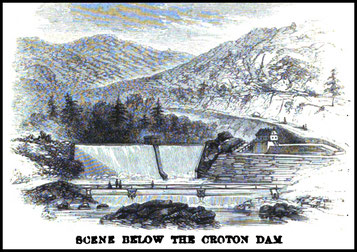
After years of study and planning, city voters approved the Croton Aqueduct in elections held on April 14-16, 1835, by a vote of 17.330 to 5.963. The following year, John B. Jervis was chosen as the chief engineer on the Aqueduct. Construction began in 1837 and this first, or Old Croton, Aqueduct, was placed in service on June 22, 1842 at a cost of just under $9 million. A grand celebration was held on October 14, 1842. A receiving reservoir was built in Central Park south of 86th Street (discontinued in 1925) and a distribution reservoir was located in Manhattan's Murray Hill between 41st and 42nd Street on Fifth Avenue. The water was withdrawn from the distribution reservoir on December 18, 1897 and it was torn down to make room for the New York Public Library. Some foundations of the reservoir are still visible on the lower level of the library building.
Croton Falls
Originally called Owenville, for early mill owner John Owen, the hamlet was renamed Croton Falls when the railroad came in 1846. As in Purdys Station, development quickly followed the arrival of the train. With the opportunity to ship directly to the city (replacing the tedious overland route to Sing Sing and the Hudson River), manufacturers built factories and mills to make everything from paper and lumber to toys and machine parts. Passenger service to and from the city meant hotels and shops would be needed for vacationers headed to Peach Lake. Like his second cousin Isaac Hart Purdy, Joel Purdy saw opportunity. He had grown up in town, had become a successful businessman in the city and decided to bring his entrepreneurship home. Joel built many of the stores on Front Street, at least 14 houses, barns, stables, factories, a plaster mill and a grand house for his family: The 1864 House, now Prima Vera Restaurant. The little village thrived. Then the expansion of the reservoir system took its toll. Homes on Routes 100 and 22 were lost, the Presbyterian Church was moved and many mills were forced to close.
One Purdy mill had been leased to the Juengst family, when they lost access to water power in Somers for their Empire Sewing Machine Company. The Juengsts purchased water rights up the river for future mills and built homes on the east side of 22 north of town. The Juengsts provided many jobs as they expanded their businesses to include machines for metal work and book binding. They also brought the first electric service to town.
Historic Landmarks of the Town of North Salem, New York

Joel Purdy was engaged in business in New York for many years and amassed a competence, after which he returned to his native town and erected the fine residence
At Croton Falls, New York, on Sunday morning, February 7, 1897, died Joel B. Purdy, aged 90 years. Funeral Tuesday from his late home at 1:30 o'clock PM, Interment in Ivandell Cemetery. Carriages in waiting at the station on arrival of train leaving Grand Central Depot at 10:50 A.M.